Area 1: External Drivers of Change

Objectives Progress Report Publications Show All  

External Drivers of Change

Our goal for this area is to characterize external drivers such as climate change, sea-level rise, and human alterations of the landscape in terms of long-term trends, spatio-temporal variability, and occurrence of extreme events (e.g., storms, droughts) so that we can investigate the links between external drivers and ecosystem response. This includes collecting ongoing information on climate and oceanographic conditions, sea level, and river discharge (Fig 1).

Research Objectives

A) Environmental Drivers

  • 1A.1 - Collect ongoing information on climate and oceanographic conditions, sea level, and river discharge
  • 1A.2 - Maintain eddy covariance tower in Duplin River
  • 1A.3 - Monitor Altamaha River water entering the GCE domain
  • 1A.4 - Conduct dendrochronology analysis

B) Human Drivers

  • 1B.1 - Assess Native American oyster harvesting practices
  • 1B.2 - Evaluate how human activity relates to marsh inundation patterns
  • 1B.3 - Track shoreline armoring

Current Progress Report

Below is an update for each of the Area 1 objectives as reported in the most recent annual report. For a list of all reports click here (Annual Reports).

A) Environmental Drivers

  • 1A.1 - Collect ongoing information on climate and oceanographic conditions, sea level, and river discharge

      Activities:  We use several meteorological stations to characterize the GCE domain (Fig. 1), including climate data collected at Marsh Landing and the GCE flux tower. We also track sea level (including a GCE tide gage), offshore wind forcing, and river discharge.

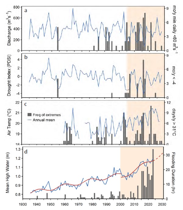
      Significant Results:  We have done a detailed analysis of the increase in flooding events and the effect of the lunar nodal cycle on sea level in the GCE domain (Fig. 2).

Area 1 Figure 1

Fig1. Locations of observing stations used for boundary conditions (ML is Marsh Landing; UGAMI is UGA Marine Institute).

Area 1 Figure 2

Fig. 2. Distribution of highest daily water levels for each 9-year half-cycle of the lunar nodal cycle. The orange vertical line is at 0.55 m above MHHW, which is the NOAA threshold for minor flooding. Source: D. Di Iorio.

  • 1A.2 - Maintain eddy covariance tower in Duplin River

      Activities:  The GCE flux tower measures CO2/H2O, weather conditions, radiation, water levels, and soil temperature. This year we re-installed a boardwalk for tower access with minimal disturbance.

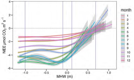
      Significant Results:  We are using footprint modeling and eddy covariance fluxes to derive estimates of net ecosystem exchange (NEE) in the marsh landscape (Fig. 3), and conducting a cross-site comparison of the timing of C flux source/sink transitions with sites in SC, DE, and MA.

Area 1 Figure 3

Fig. 3. We are using flux footprint modeling and eddy covariance fluxes to scale up tower-based NEE to the marsh landscape. Source: Hawman et al., in review

  • 1A.3 - Monitor Altamaha River water entering the GCE domain

      Activities:  We collect monthly samples of water entering the GCE domain via the Altamaha River for analysis of dissolved inorganic and organic nutrients, DIC and alkalinity, and added d13C-DIC this year.

      Significant Results:  Stadler et al. (2023) analyzed dissolved organic matter from a wide range of river systems, including the Altamaha, and identified characteristics of both rare and common constituents. Core compounds had low molecular mass, low oxidation state, and a high degree of aromaticity.

  • 1A.4 - Conduct dendrochronology analysis

      Activities:  We completed a high-resolution radiocarbon dating project to anchor the dendrochronological sequence of the Georgia Coast.

      Significant Results:  We have found evidence for the effect of sea level changes on tree die-offs.

B) Human Drivers

  • 1B.1 - Assess Native American oyster harvesting practices

      Activities:  We now have a high-resolution chronology for oyster harvests over the past 5000 years.

      Significant Results: Our archaeological studies establish that indigenous inhabitants lived within a fluctuating coastal environment (see Key Accomplishments).

  • 1B.2 - Evaluate how human activity relates to marsh inundation patterns

      Activities:  We monitor flooding of upland populated areas on Sapelo Island via legacy infrastructure (drainage canals). We also identified participants for interviews and snowball sampling (Supplement to SSU).

      Significant Results:  Water level data from drainage canals suggest that they increase upland flood risk by connecting otherwise disconnected low-lying areas and decreasing the friction of tidal flow.

  • 1B.3 - Track shoreline armoring

      Activities:  Our last assessment was in 2018, with the next one targeted for 2024.

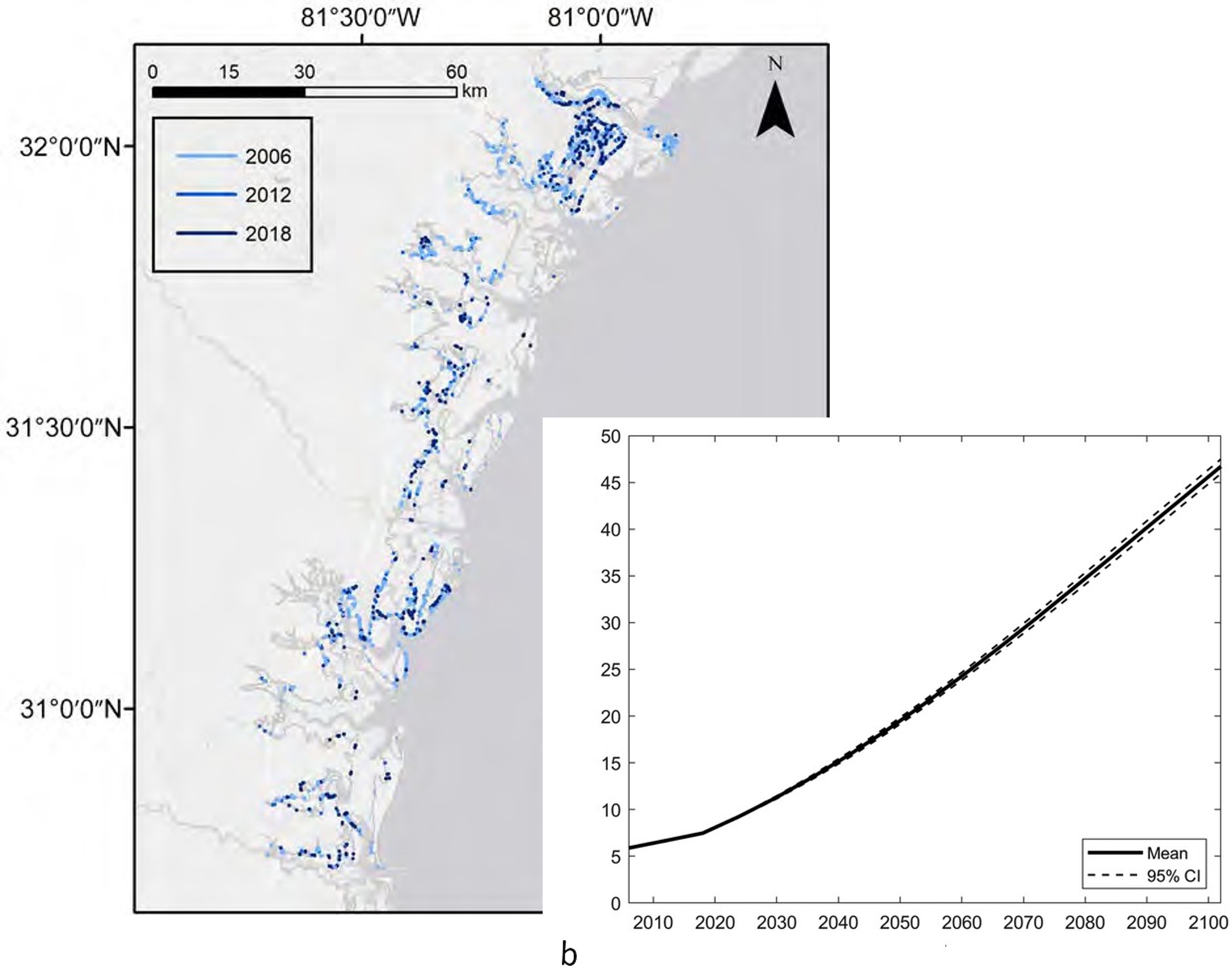
      Significant Results: Between 2006 and 2018, the number of structures in McIntosh County, where the GCE is located, has risen by 66%, and the total length of structures has increased by 39%.

Area 1 Publications from GCE-IV

Robinson, M., Alexander, C.R. Jr. and Venherm, C. 2022. Shallow Water Estuarine Mapping in High-Tide-Range Environments: A Case Study from Georgia, USA. Special Issue: Shallow Water Mapping. Estuaries and Coasts. 45:980-999. (DOI: https://doi.org/10.1007/s12237-021-01032-y)

Hardy, D. and Heynen, N. 2021. "I am Sapelo": Racialized Uneven Development and Land Politics within the Gullah/Geechee Corridor. Environment and Planning E: Nature and Space. 5(1):401-425. (DOI: 10.1177/2514848620987366)

Ritchison, B.T., Thompson, V.D., Lulewicz, I.H., Tucker, B. and Turck, J.A. 2021. Climate Change, Resilience, and the Fisher-Hunter-Gatherers of Late Holocene Georgia Coast. Quaternary International. (DOI: 10.1016/j.quaint.2020.08.030)

Burns, C., Alber, M. and Alexander, C.R. Jr. 2020. Historical Changes in the Vegetated Area of Salt Marshes. Estuaries and Coasts. (DOI: https://doi.org/10.1007/s12237-020-00781-6)

Crotty, S.M., Ortals, C., Pettengill, T.M., Shi, L., Olabarrieta, M., Joyce, M.A., Altieri, A.H., Morrison, E., Bianchi, T.S., Craft, C.B., Bertness, M.D. and Angelini, C. 2020. Sea-level rise and the emergence of a keystone grazer alter the geomorphic evolution and ecology of southeast US salt marshes. PNAS. 117:17891-17902. (DOI: https://doi.org/10.1073/pnas.1917869117)

Heynen, N. 2020. A plantation can be a commons: Re-Earthing Sapelo Island through Abolition Ecology. Antipode. 0(0):20. (DOI: 10.1111/anti.12631)

Thompson, V.D., Rick, T., Garland, C.J., Thomas, D.H., Smith, K.Y., Bergh, S., Sanger, M., Tucker, B., Lulewicz, I.H., Semon, A.M., Schalles, J.F., Hladik, C.M., Alexander, C.R. Jr. and Ritchison, B.T. 2020. Ecosystem stability and Native American oyster harvesting along the Atlantic Coast of the United States. Science Advances. 6. (DOI: 10.1126/sciadv.aba9652)

Letourneau, M.L. and Medeiros, P.M. 2019. Dissolved organic matter composition in a marsh-dominated estuary: Response to seasonal forcing and to the passage of a hurricane. Journal of Geophysical Research: Biogeosciences. 124:1545-1559. (DOI: 10.1029/2018JG004982)

Napora, K., Cherkinsky, A., Speakman, R.J., Thompson, V.D., Horan, R. and Jacobs, C. 2019. Radiocarbon Pretreatment Comparisons of Bald Cypress (Taxodium distichum) Wood Samples from a Massive Buried Deposit on the Georgia Coast, USA. Radiocarbon. 61:1755-1763.

Turck, J.A. and Thompson, V.D. 2019. Human-Environmental Dynamics of the Georgia Coast. In: Reeder-Myers, L., Turck, J. and Rick, T. (editors). The Archaeology of Human-Environmental Dynamics on the North American Atlantic Coast. University Press of Florida, Gainesville, GL.

Napora, K. 2021. Refining cultural and environmental temporalities at the late Archaic-early woodland transition along the Georgia coast, UGA. Ph.D. Dissertation. University of Georgia, Athens, GA. 211 pages.

Bailey, M. and Heynen, N. 2020. Sweet (and sticky) redemption. In: Scalawag Magazine.

Area 1 Publications from GCE-III

Journal Articles

Narron, C., O'Connell, J.L., Mishra, D., Cotten, D.L., Hawman, P. and Mao, L. 2022. Flooding in Landsat across tidal systems (FLATS): An index for intermittent tidal filtering and frequency detection in salt marsh environments. Ecological Indicators. 141:109045. (DOI: 10.1016/j.ecolind.2022.109045)

Nahrawi, H.B., Leclerc, M.Y., Pennings, S.C., Zhang, G., Singh, N. and Pahari, R. 2020. Impact of tidal inundation on the net ecosystem exchange in daytime conditions in a salt marsh. Agricultural and Forest Meteorology. 294:108133. (DOI: https://doi.org/10.1016/j.agrformet.2020.108133)

Dugan, J., Emery, K., Alber, M., Alexander, C.R. Jr., Byers, J., Gehman, A., McLenaghan, N.A. and Sojka, S. 2018. Generalizing Ecological Effects of Shoreline Armoring Across Soft Sediment Environments. Estuaries and Coasts. 41(1):180-196. (DOI: 10.1007/s12237-017-0254-x)

Gehman, A., McLenaghan, N.A., Byers, J., Alexander, C.R. Jr., Pennings, S.C. and Alber, M. 2018. Effects of small-scale armoring and residential development on the salt marsh-upland ecotone. Estuaries and Coasts. 41(1):54-67. (DOI: 10.1007/s12237-017-0300-8)

O'Connell, J. and Alber, M. 2016. A smart classifier for extracting environmental data from digital image time-series: Applications for PhenoCam data in a tidal salt marsh. Environmental Modelling & Software. 84:134-139. (DOI: 10.1016/j.envsoft.2016.06.025)

Sheldon, J.E. and Alber, M. 2006. The calculation of estuarine turnover times using freshwater fraction and tidal prism models: a critical evaluation. Estuaries and Coasts. 29(1):133-146.

Sheldon, J.E. and Alber, M. 2002. A comparison of residence time calculations using simple compartment models of the Altamaha River estuary, Georgia. Estuaries. 25(6B):1304-1317.

Conference Papers (Peer Reviewed)

Sheldon, J.E. and Alber, M. 2005. Comparing Transport Times Through Salinity Zones in the Ogeechee and Altamaha River Estuaries Using SqueezeBox. In: Hatcher, K.J. (editor). Proceedings of the 2005 Georgia Water Resources Conference. Institute of Ecology, University of Georgia, Athens, Georgia.

Sheldon, J.E. and Alber, M. 2003. Simulating material movement through the lower Altamaha River Estuary using a 1-D box model. Hatcher, K.J. (editor). Proceedings of the 2003 Georgia Water Resources Conference. Institute of Ecology, University of Georgia, Athens, Georgia.

Blanton, J.O., Alber, M. and Sheldon, J.E. 2001. Salinity response of the Satilla River Estuary to seasonal changes in freshwater discharge. Pages 619-622 in: Hatcher, K.J. (editor). Proceedings of the 2001 Georgia Water Resources Conference. Institute of Ecology, University of Georgia, Athens, Georgia.

Conference Posters and Presentations

Dugan, J., Alber, M., Alexander, C.R. Jr., Byers, J., Emery, K., Gehman, A., Lawson, S. and McLenaghan, N.A. 2015. Poster: A conceptual model for predicting the ecological effects of coastal armoring in soft-sediment environments. Coastal and Estuarine Research Federation Biennial Meeting, August 30 - September 2, 2015, Estes Park, CO.

Dugan, J., Alber, M., Alexander, C.R. Jr., Byers, J., Emery, K., Gehman, A., Lawson, S. and McLenaghan, N.A. 2015. Poster: A conceptual model for predicting the ecological effects of coastal armoring in soft-sediment environments. Coastal and Estuarine Research Federation Biennial Meeting, November 8-12, 2015, Portland, OR.

Gehman, A., McLenaghan, N.A., Byers, J., Alexander, C.R. Jr., Pennings, S.C. and Alber, M. 2015. Poster: Effects of development and shoreline armoring on the high marsh ecosystem. Benthic Society Ecology Meeting 2015, March 4-7, 2015, Quebec City, CN.

Sheldon, J.E. and Burd, A.B. 2009. Presentation: An In-depth Look at Alternating Effects of Climate Signals on Freshwater Delivery to Coastal Georgia, U.S.A. Hydrologic Prediction in Estuaries and Coastal Ecosystems. CERF 2009: Estuaries and Coasts in a Changing World, November 1-5, 2009, Portland, OR.

Sheldon, J.E. and Burd, A.B. 2007. Poster: Detecting climate signals in river discharge and precipitation data for the central Georgia coast. 2007 AERS/SEERS Meeting, March 15-17, 2007, Pine Knoll Shores, NC.

Alber, M. and Sheldon, J.E. 2006. Calculating estuary turnover times during non-steady-state conditions using freshwater fraction techniques. Southeastern Estuarine Research Society meeting, Ponte Vedra Beach, Florida.

Alber, M. and Sheldon, J.E. 2006. Presentation: Simple tools for assessing coastal systems: can we get there from here? Coastal Observing Systems Workshop, LTER All Scientists Meeting, September 20-24, 2006, Estes Park Colorado.

Sheldon, J.E. and Alber, M. 2005. Poster: New and improved: Modeling mixing time scales in the Altamaha River estuary. GCE-LTER 2005 Annual Meeting. GCE-LTER, Feb. 11-12, 2005, Athens, Georgia.

Sheldon, J.E. and Alber, M. 2005. Presentation: Beyond whole-estuary flushing times: Using transport times through salinity zones to explain chlorophyll patterns in the Altamaha River estuary (Georgia, USA). Estuarine Interactions: biological-physical feedbacks and adaptations. 2005 Estuarine Research Federation Meeting. October 16-20, 2005, Norfolk, Virginia.

Sheldon, J.E. and Alber, M. 2004. Presentation: SqueezeBox: Flow-scaled 1-D box models for estuary residence time estimates. NOS Workshop on Residence/Flushing Times in Bays and Estuaries. National Oceanic and Atmospheric Administration, June 8-9, 2004, Silver Spring, Maryland.

Sheldon, J.E. and Alber, M. 2004. Presentation: SqueezeBox: Flow-scaled 1-D box models for estuary residence time estimates. Spring 2004 meeting. Southeastern Estuarine Research Society (SEERS), October 14-16, 2004, Wilmington, North Carolina.

Sheldon, J.E. and Alber, M. 2003. Poster: Modeling mixing time scales and transport of dissolved substances in the Altamaha River estuary. 2003 LTER All Scientist's Meeting, "Embarking on a Decade of Synthesis". LTER, Sept. 18-21, 2003, Seattle, Washington.

Sheldon, J.E. and Alber, M. 2003. Presentation: The equivalence of estuarine turnover times calculated using fraction of freshwater and tidal prism models. 2003 Estuarine Research Federation meeting, Sept. 14-18, 2003, Seattle, WA.

Sheldon, J.E. and Alber, M. 2001. Poster: Any way you slice it: A comparison of residence time calculations using simple compartment models of the Altamaha River estuary. ERF 2001: An Estuarine Odyssey (16th Biennial Conference of the Estuarine Research Federation). Freshwater Inflow: Science, Policy and Management. Estuarine Research Federation, Nov. 4-8, 2001, St. Pete Beach, Florida.

Alber, M. and Sheldon, J.E. 2000. Presentation: Residence times in the Altamaha River Estuary: a progress report. Southeastern Estuarine Research Society Meeting. Southeastern Estuarine Research Society, Oct 01, 2000, Tampa, Florida.

Newsletter and Newspaper Articles

Sheldon, W.M. Jr. 2006. Mining and Integrating Data from ClimDB and USGS using the GCE Data Toolbox. In: DataBits: An electronic newsletter for Information Managers: Spring 2006. Long Term Ecological Research Network, Albuquerque, NM.

 
LTER
NSF

This material is based upon work supported by the National Science Foundation under grants OCE-9982133, OCE-0620959, OCE-1237140 and OCE-1832178. Any opinions, findings, conclusions, or recommendations expressed in the material are those of the author(s) and do not necessarily reflect the views of the National Science Foundation.