Marsh Sediment Dynamics
|
Estuarine wetlands occupy the dynamic interface between land and sea. They persist in the face of rising sea level and episodic disturbance (hurricanes) that is driven by regular pulsing of the tides and irregular pulsing from freshwater (river flooding and rainfall) sources. The ability of estuarine marshes to grow upwards or accrete vertically is driven by both physical and biogenic processes. Long-term marsh accretion is controlled by inputs of mineral sediment and in situ production and accumulation of organic matter in soil. Deposition of mineral sediment is driven by freshwater input during annual cycles of river flooding that deposits fine sediment (silt, clay) on the marsh surface. Over longer time-scales, hurricanes may deposit marine sediment that is coarser (sandier) onto seaward marshes. Marsh stability also is controlled by belowground biomass production of emergent vegetation and accumulation as organic matter in soils. |
|
|
|
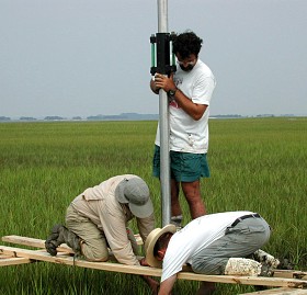
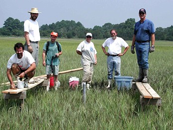
The combined effect sediment deposition and in situ organic matter accumulation on marsh accretion and subsidence are measured with sediment-erosion tables (SET's) established in each marsh (Boumanns and Day 1993). The SET consists of a fixed elevation benchmark constructed using aluminum pipe sunk 10-20 feet into the soil and filled with concrete. Periodically, usually every six months, a measuring device (the SET "head") is placed on top of the benchmark and a series of measurements (36 in all) are made at fixed angles and distances within 2 meters of the benchmark. Repeated measurements made at fixed points in the marsh enable us to quantify small-scale changes in marsh accretion and subsidence over time. |
|
Reference: Boumans, RMJ and JW Day, Jr. 1993. High precision measurements of sediment elevation in shallow coastal areas using a sedimentation-erosion table. Estuaries 16:375-380. |
|